3rd grade - Our Global Community - What's the Connection? Locke and Kokx

Day 7:
More maps of countries:
http://go.hrw.com/atlas/norm_htm/world.htm (find your continent and then find your country)
Day 6:
Working with Google Docs - Today we logged into Google Docs and created a new document. We named the document and typed a paragraph about ourselves. Then we began looking at the formatting tools and how to use them. We learned how to make text bigger, bolder, underlined, italicized, and colored. We're doing this to prepare for typing out our country reports.
Day 5:
Introducing Google Docs
Google Earth
Day 4:
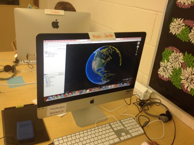
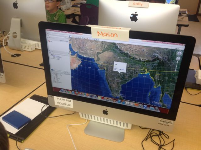
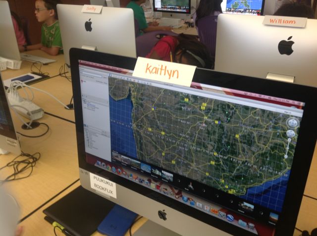
Today we're going to use Google Earth to locate your country.
Day 3:
Getting Started:
What is Geo-literacy? Interactions (systems), Interconnections (reasoning), Implications (decision-making)
What is a continent?
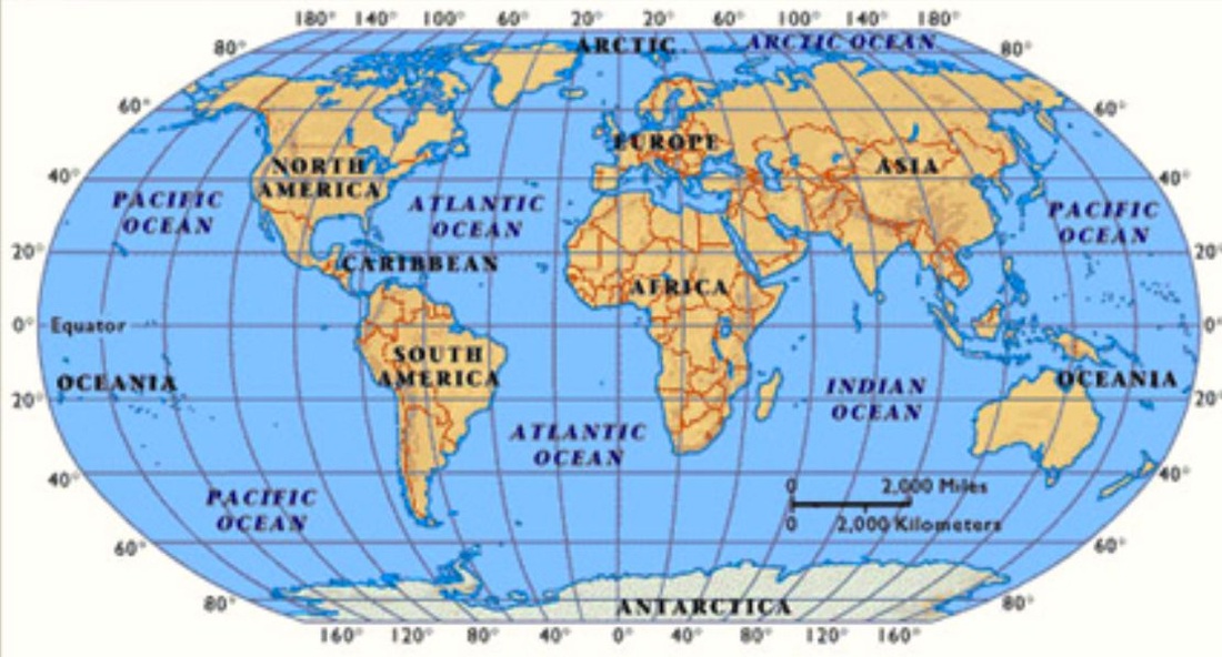
Today we're going to work on locating where our countries are on the world map. We'll explore latitude and longitude and then use that information to find our countries. You'll finish with a mini-quiz about your country.
More maps of countries:
http://go.hrw.com/atlas/norm_htm/world.htm (find your continent and then find your country)
Day 6:
Working with Google Docs - Today we logged into Google Docs and created a new document. We named the document and typed a paragraph about ourselves. Then we began looking at the formatting tools and how to use them. We learned how to make text bigger, bolder, underlined, italicized, and colored. We're doing this to prepare for typing out our country reports.
Day 5:
Introducing Google Docs
- how to log in
- create a document
- name document
- Tools > Research
- Search for Images related to your country- Royalty free and drag into document (notice citation) - wrap or no wrap? inline or no inline?
Google Earth
- Tour your country (toolbar at bottom of page)
Day 4:
Today we're going to use Google Earth to locate your country.
- Enter the name of your country into the Google Earth Search Box.
- Make sure that the grid is turned on (View-Grid). Write down your country's Latitude and Longitude (approximately at the center of your country.
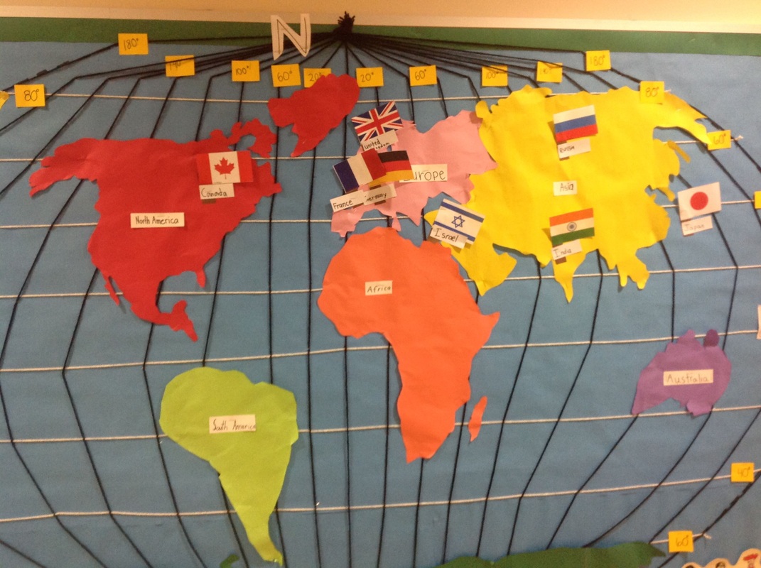
- Go to http://www.theodora.com/flags/ and find your country's flag. From our printed out flags, find your country's flag and put your flag on the world map in the hallway with a label for your country.
- Mini-quiz - finish with a mini-quiz about your country. Take me to the quiz.
- If you finish, you can return to Google Earth and explore your country. Use the tour guide to explore highlights of your country.
Day 3:
Getting Started:
What is Geo-literacy? Interactions (systems), Interconnections (reasoning), Implications (decision-making)
What is a continent?
Today we're going to work on locating where our countries are on the world map. We'll explore latitude and longitude and then use that information to find our countries. You'll finish with a mini-quiz about your country.
- About latitude and longitude (flash interactive)
- Brainpop - Latitude and Longitude (you watched this last week)
- Go to Google Earth (make sure the grid is turned on - View - Grid) and find the Latitude and Longitude for your country (work with your partners). Look for the center of you country and find the latitude (N/S) and the longitude (E/W) for your country. Write these down.
- Go to http://www.theodora.com/flags/ and find your country's flag. From our printed out flags, find your country's flag and put your flag on the world map in the hallway with a label for your country.
- Mini-quiz - finish with a mini-quiz about your country. Take me to the quiz.
- ABCya.com practice with latitude and longitude
- KidsGeo.com - Latitude and Longitude game
- Maps of the World - find your country
Day 2:
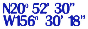
1. What could these numbers mean?
We worked with our partners to brainstorm what these letters, numbers and symbols might mean. Do you know what they could be?
2.Then we opened Google Earth and we typed in the numbers, letters and symbols.Using Google Earth we:
3. Brainpop - Latitude and Longitude
4. Complete three people holding hands.
Day 1:
1. Pre-assessment: Click here to take the mini-pre-assessment for our project.
2. We're going to begin our Global Community Project by creating images of children holding hands. To do this we'll be using the graphics tablets and KidPix.
Your task:
1. What could these numbers mean?
We worked with our partners to brainstorm what these letters, numbers and symbols might mean. Do you know what they could be?
2.Then we opened Google Earth and we typed in the numbers, letters and symbols.Using Google Earth we:
- Explored zooming in and out
- Explored street view
- Turned on Roads (Layers)
- Turned on the Navigation (View)
- Turned on the Sun (Top toolbar)
- Turned on the Grid (View)
3. Brainpop - Latitude and Longitude
4. Complete three people holding hands.
Day 1:
1. Pre-assessment: Click here to take the mini-pre-assessment for our project.
2. We're going to begin our Global Community Project by creating images of children holding hands. To do this we'll be using the graphics tablets and KidPix.
Your task:
- Open KidPix and using a thin, black, pencil draw the outline of three children holding hands (plan to use about 2/3 of the workspace - think ahead to how big your people need to be.
- Use the paint (fill) bucket to fill in skin tones, and clothes.
- You will not be adding background color.
- When your picture is complete you'll print it to the Lab-Phaser - no laminate and you'll choose Tray 1 for the Paper Feed
- After you print your picture, you'll cut out around the top of your people and then staple it to our class bulletin board.
3rd grade - Our Global Community - What's the Connection? - Kamala's Class
Identifying our countries
Today we're going to work on locating where our countries are on the world map. We'll explore latitude and longitude and then use that information to find our countries. You'll finish with a mini-quiz about your country.
Today we're going to work on locating where our countries are on the world map. We'll explore latitude and longitude and then use that information to find our countries. You'll finish with a mini-quiz about your country.
- About latitude and longitude (flash interactive)
- Brainpop - Latitude and Longitude
- Go to Google Earth and find the Latitude and Longitude for your country (work with your partners). Look for the center of you country and find the latitude (N/S) and the longitude (E/W) for your country. Write these down.
- Go to http://www.theodora.com/flags/ and find your country's flag. From our printed out flags, find your country's flag and put your flag on the world map in the hallway with a label for your country.
- Mini-quiz - finish with a mini-quiz about your country. Take me to the quiz.
- ABCya.com practice with latitude and longitude
- KidsGeo.com - Latitude and Longitude game
- Maps of the World - find your country
|
Building our World
This week we formed our groups and figured out what our countries were. We began working with longitude and latitude as we put them on our world. Today's agenda:
|
New Vocabulary
Map 1
Map 2
|
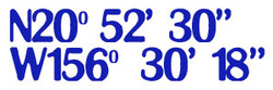
What could these numbers mean?
We worked with our partners to brainstorm what these letters, numbers and symbols might mean. Do you know what they could be?
Then we opened Google Earth and we typed in the numbers, letters and symbols.
We worked with our partners to brainstorm what these letters, numbers and symbols might mean. Do you know what they could be?
Then we opened Google Earth and we typed in the numbers, letters and symbols.
|
Using Google Earth we:
|
What is Geo-Literacy? (from National Geographic)
Why is Geo-Literacy Important? (from National Geographic) New Vocabulary Google Earth |
